Zahilyn Allred anxiously waited over a week before she received the call.
"My dad finally called after he borrowed a coworker's phone at the hospital," Allred said. "My grandmother's house was heavily damaged, but she's okay. And with my dad working at the hospital, he was safe too. It was incredibly painful to wait for that call, though."
Allred, a graduate assistant in the Chemistry and Biochemistry department, is from Puerto Rico, where her father, grandparents, aunts, uncles and friends all experienced Hurricane Maria in her small hometown of Santa Isabel. But, even after hearing that everyone was okay, Allred is still very worried.
"It's such a small town, they won't have electricity for at least four months -- if that," Allred said. "The post office just opened yesterday, so I'm about to go buy some supplies to ship to them. But I have no idea how long it will take to get there."
But Allred continues to do what she can: a post on Facebook prompted her to reach out to Dereck Torres, a teaching assistant at the Ohio State University, who organized a massive donation network among universities in Ohio. A total of 12 pallets of donations were collected, one of which was from the Oxford community, due to Allred's involvement.
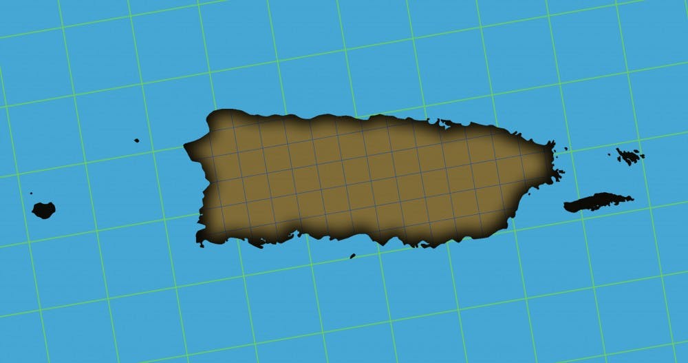
Allred also helped contribute to Miami's Mapathon: a three-hour-long event where students and faculty volunteers of all levels of experience contributed to a cohesive map that will help relief efforts on the island.
"It is hard to quantify exactly how much of the map we contributed, but the steep jump on Friday afternoon coincides with when we held the Mapathon," said Damon Scott, assistant professor of Geography and Global and Intercultural Studies. Scott organized the Mapathon last Friday.
Just over 100 students, faculty, staff and community members helped map out a southeast section of Puerto Rico using openstreetmap.org, an open-source mapping project used by the American Red Cross to help locate where structures should be in the wreckage.
"It was very similar to Google Maps," Allred said. "It wasn't very technical; anyone could do it. I mapped out my hometown."
Michigan Tech and the University of South Alabama held similar Mapathon events. Thousands of buildings were mapped in total among the three schools.
Scott believes it is imperative to note a long road to recovery lies ahead for the over 3.4 million American citizens who call the island their home.
"The Puerto Ricans are very strong people, and they will do what needs to be done," Allred said.
Enjoy what you're reading?
Signup for our newsletter
Read More


Miami baseball earns regular season MAC champions and looks to take home a second straight title
By Graham Young | May 19, 2026The Miami University RedHawks baseball team will head to the MAC tournament as the one seed for the second straight year.